
 4th October 2013
By Steven Strong and Andy Whiteley
Contributing Writers for Wake Up World
During 1939 two extremely open-minded and dedicated men spent a great deal of time trying to come to grips with what one of those men, Frederic Slater, President of the Australian Archaeological and Education Research Society, claimed to be Australia’s “Stonehenge.”[1] Countless hours were spent measuring and drawing a huge variety of stone arrangements, alignments and engravings placed above and beside a series of “terraces”[2] and “mounds.”[3]
This ancient complex, according to Slater, formed “the basis of all knowledge, all science, all history and all forms of writing, which began in numeration.”[4]

Figure 1: Computer generated image of Standing Stones[5]
Our initial tasks are simple: examine and assess the work and notes of Slater and his colleague and compare this to available archaeology and geography, oral testimonies of Original and non-Original people past and present, and as always, consult with Original Elders and Custodians before embarking upon such a daunting investigation.
[pro_ad_display_adzone id=”110028″]
We also intend to pick up from where the two men left off. First and foremost it would seem Slater’s recommended next target, the smaller 70 metre mound, is deserving of discreet excavation. Consisting of material foreign to the region, Slater claimed that the nearest site able to cater for the sandstone tonnage on site is “14 miles” away.[6] If he is correct, questions relating to extraction, metal blades and transportation in a land of sticks and stones technology need to be addressed.
What is a little more problematic is proving or refuting in absolute terms whether Slater was correct in proposing that “the mound is one of the oldest, I should say the oldest, forms of temples in the world, and dates back to the Palaeolithic age with the advent of first man.”[8] Equally, and possibly even a touch more sensational, is Slater’s belief that the most ancient of all tongues on Earth, the “Sacred Language,”[9] was first chronicled at this complex.
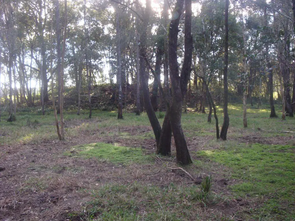
Figure 2: Smaller mound/burial site[7]
Just before anything could be resolved or formally investigated, the Second World War began, Government agencies pressured the landholder and the site was destroyed soon after. All discussion came to a close until mid-2013, when Slater’s correspondence was found amongst unmarked files in the local Historical Society.
Site Description
Very little, in terms of general location, specific soil types and geology, can be shared for fear that such information would betray either the position of this complex of “terraces,”[10] “mounds,”[11] “circles”[12] and “stone arrangements,”[13] or the landholders’ identity. All that can be said is that the site is quite remote and can be found within 40 kilometres of Mullumbimby NSW.

Figure 3 (Map 1): western slope of bigger mound[14]
The bigger mound is on a westerly slope and the smaller mound was built on top of a level swampy plain of black/grey loam. On parts of this flat wide plain, sugar cane is grown and the slopes that are cleared are carrying beef cattle. The alignment and distance from the ocean is known, but again sharing such information achieves nothing bar narrowing down possibilities and geography. What can be stated with absolute certainty is that this area contains no natural deposit of sandstone, while igneous rocks, some weighing hundreds of kilograms, can be found across all slopes and gullies and throughout the level paddocks.
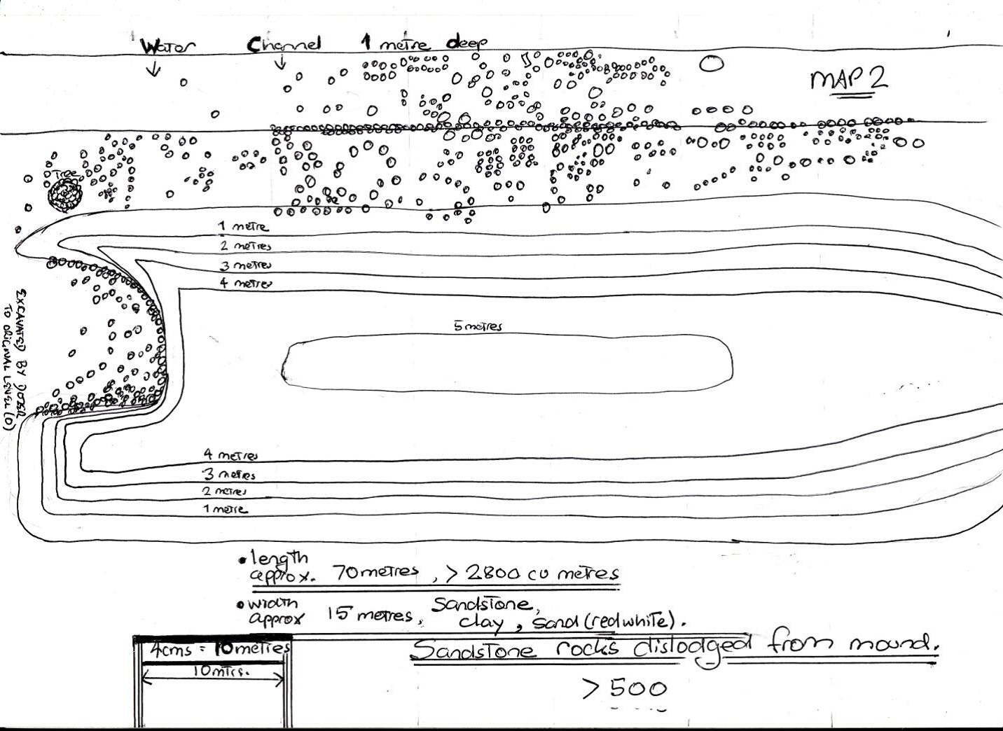
Figure 4 (Map 2): Smaller mound and scatter of sandstone rocks[15]
On the two days we were permitted to conduct archaeology, the two mounds (see Maps 1 and 2) were of particular interest. The smaller mound, which is approximately 70 metres long and 5 metres high, seems in opposition with the surrounding landscape. There are hundreds of hectares of flat land all around, and this mound is at least 50 metres from any natural slope.
A variety of commentators had made note of the obvious artificial nature of this construction. A teacher from a nearby school, who was following up on the scant details still available in 1964, made reference to “the presence of a single mound of this type in an entire swampy flood plain, the locals say imported. So far I have not had time to carry out a profile examination, but again our geographers on staff cannot understand its presence.”[16] Even though the teacher maintained a degree of skepticism, he posed a rhetorical question that we must attempt to answer:
“How can a natural line of small sandstone pieces suddenly appear in a line and on a mound in a swamp when all surrounding rocks are igneous?” [17]
The much larger mound, which spans well over one hundred metres, was originally the place where the Standing Stones were carefully positioned and realigned throughout the year. Not only were all the stones of this construction and the many other arrangements nearby bulldozed and disc ploughed, it seems the actual mound itself was cleared of stones and ‘de-terraced.’
In one of Slater’s first letters to his on-site colleague, he not only asks “how many terraces on the mound,”[18] but reminds him if he can “ascertain the number of terraces on the hillside”[19] it would solve one of the many riddles associated with this site. He privately hoped that there were “six terraces.”[20] Further on, he requests that more investigation into the terracing be done, suggesting that if the terraces have “wavy lines”[21] it may “indicate something flowing or moving onwards.”[22]
Even though all signs of the terraces are gone, not so the displaced rocks that were on the mound. They are spread all over the slopes of the larger mound and some can be found down on the flats, over 50 metres from their original position. A large proportion of the sandstone rocks that are easily seen, seem to have worked edges, flat sides and straight lines, but bear no impact or percussion marks as would be expected if fashioned by rock tools. Apart from the two mounds and hundreds of sandstone rocks, no other stone arrangements or unusual formations are apparent.
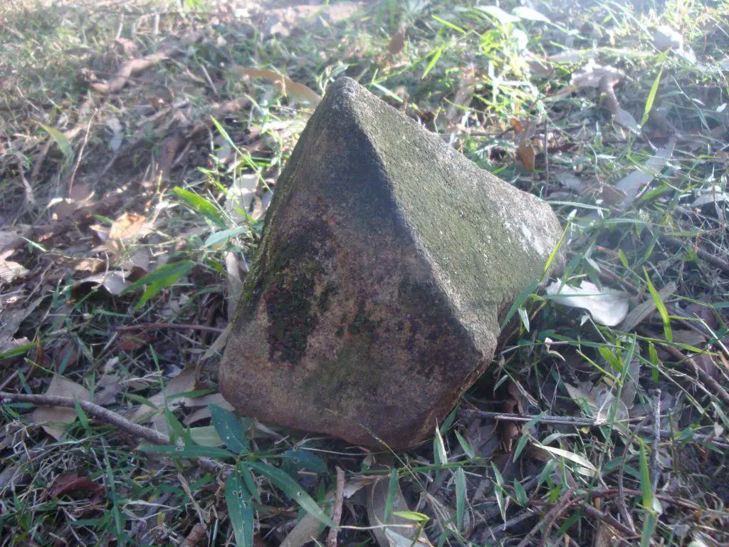
Figure 5: Sandstone “shaped stones”[23]

Figure 6: Sandstone “shaped stones”[24]
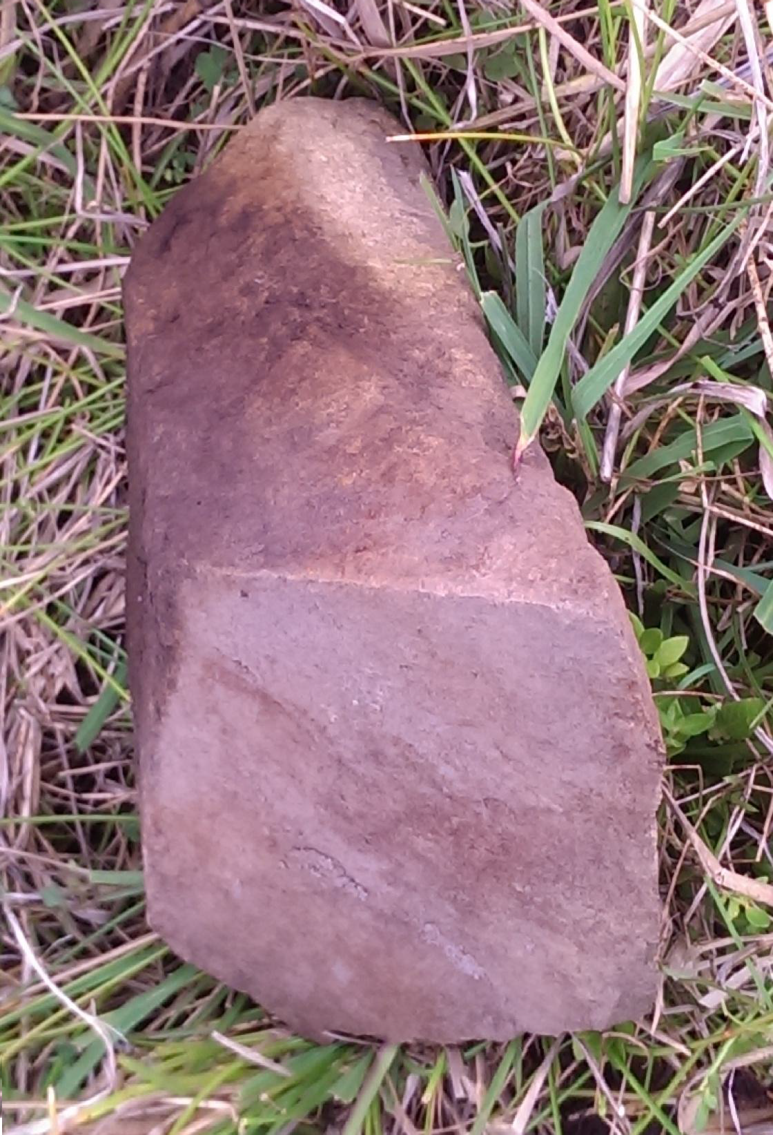
Figure 7: Sandstone “shaped stones”[25]
Methodology
Slater’s work was nowhere near complete, and when first establishing a working relationship with his colleague on site, he set out 15 “points to look for in searching for facts connected with the XXXXXXX circles, terraces and mounds.”[26] Due to the phenomenal overload of sites and stone arrangements most of these points were not addressed, particularly when it came to conducting any archaeology on either mound beyond charting the positions of each rock and determining its meaning.
It was our intention to dig three small pits, one on top of, another at the edge of, and the third 15 metres away from the smaller mound. The off-site trench is important in establishing what the natural soil is, and whether there are deeper deposits of sand and sandstone similar to the material inside the mound. One smaller trench needs to be dug at a location where the mound finishes and the natural soil is re-established, we will be searching for the layer of original soil (grey/black loam) which we believe sits under the mound, thus proving this material was placed above the natural topsoil. Finally, and with the utmost trepidation, we intend to dig from the very top of the mound to analyse the materials used as fill with the possibility of dating material by use of either Carbon 14 or Thermoluminesence dating technologies.
We also needed, in the most approximate terms, an estimate of the amount of exotic material found within the mound and will need measurements of length, width and height. But we also have to factor into our calculations the gradual slope on the eastern side and much steeper rise on the western side.
Any thought of excavating one thimble of soil from the larger mound was always dependent on what took place once the Elders and Custodians stood on the bigger mound. From the time the eight hawks circled above, the prospect of turning over one sod of earth from this mound was never going to part of our two days on site.
Even though Slater’s colleague surveyed the area for sandstone deposits of any size, and made claim that the nearest deposit was at least “14 miles away,”[27] one group was sent out to check every ridge and the flat area for any sign of sandstone (and any other formations or anomalies).
After considerable negotiation, all women were restricted to the lower parts of the slope, which was more clustered and intense in sandstone rocks. Their brief was to count, observe and GPS-mark all visible rocks. They were not allowed to touch or move any rock, just record. Further up the rise on the plateau was the place where men danced and sung ceremonies in the Sacred, First Language, and because of this the top of the mound is taboo to all women past and present. The future, as always, is unknown.
To begin with, excavating three trenches near and on the smallest mound was our highest priority. Apart from the chance of establishing its age through organic matter, lack of exposure to sunlight and decay of rocks, we had to determine whether the mound is a combination of soil, sandstone, clay and sand, and how different this exotic mixture is to the surrounding geology.
The southern section of the smaller mound has been extensively damaged through excavating the sandstone and sand to use as road-fill. Unlike the natural soil, the material in the mound is very porous and an excellent road base to use on soggy flat plains. Behind the mound is a level flat section of 2 metres, then a drainage ditch used to divert the build up of stagnate water. The area (3 metres x 70 metres) is strewn with sandstone pieces of various sizes and numbers at least 500.
Unlike our count of all sandstone rocks that tumbled down the southern section of the bigger mound (of which every rock will be assigned elevation and GPS co-ordinates) it is my expectation the sandstone behind this mound was fill, and will not show indications of a human hand and tool or message. As such, a mud map, although still to scale and fairly exact in positioning, is sufficient for our purposes as long as the count is careful.
Results
Of the three trenches, only one was excavated as expected, another was hastily convened and barely scratched the surface, while the third never even reached ‘first base’, especially since two of the three people assigned this spot downed tools and walked off site vowing never to dig there.
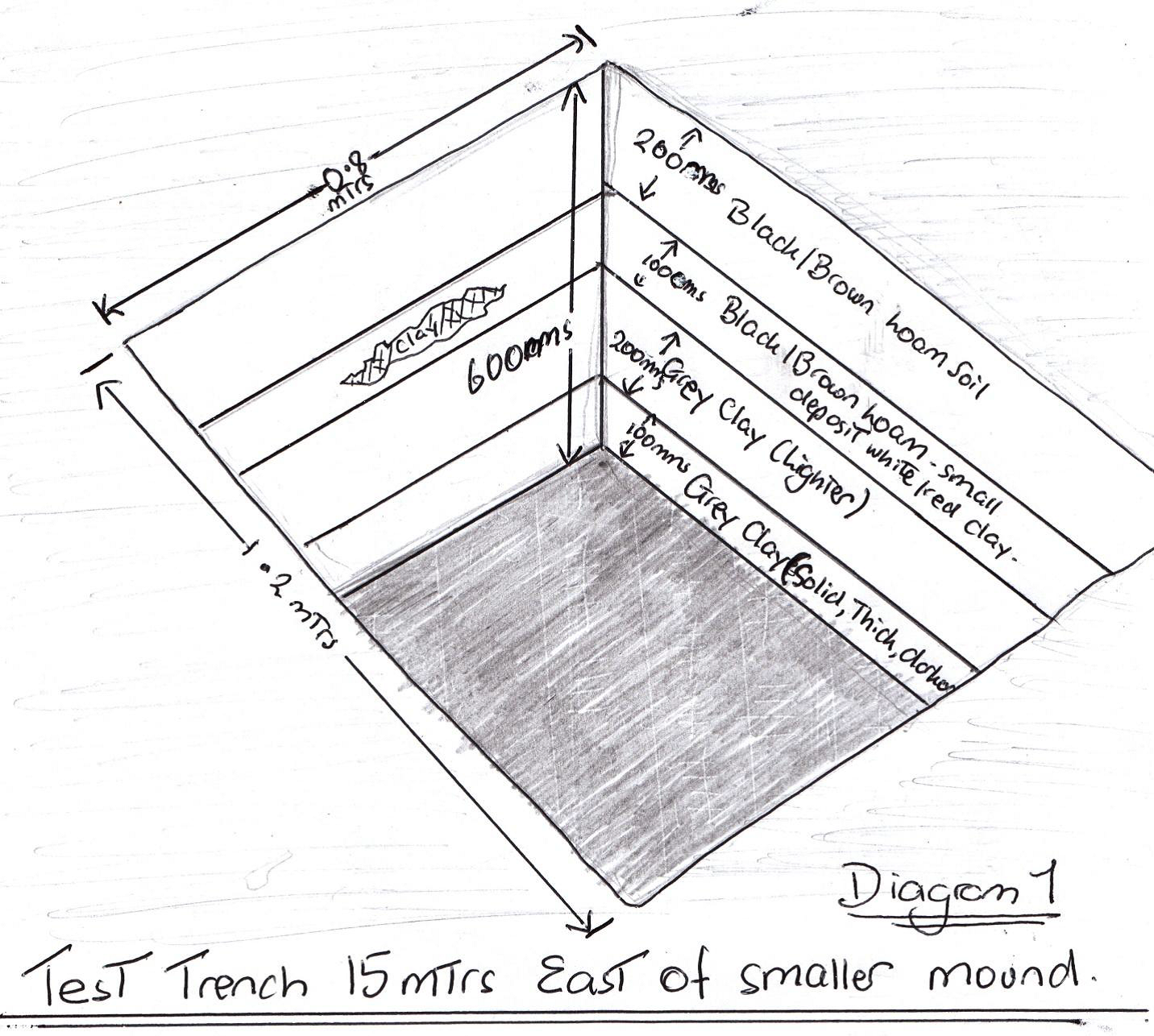
Figure 8 (Diagram): Test Trench[28]
To begin with, we will lead off with the only successful task completed with a spade, the test trench which was situated 15 metres east of the smaller mound (see Diagram). The trench is 1.2 metres x 0.8 metres and 60 cms deep. There are 4 distinct layers of soil evident, the first and most recent is a 20 cm layer of black/grey loam. Beneath that layer there is a smaller 10 cm layer of the same type of soil, but with a browner tinge and one small isolated deposit of a clump of white and red clay. There is no other clay like this on any of the four sides of this rectangular trench. The third layer is a 20 cm mixture of lighter grey clay and loam, while the last layer (which could run much deeper) of 10 cms is also grey clay, but is more dense and darker with less loam.

Figure 9: Test trench[29]
Unlike the bulldozed far southern section of the smaller mound, which is entirely made up of sandstone, white and red sand, and clay, the black loam and grey clay that makes up the surrounding soil is present and accounted for at every location except the small mound.
Our least successful excavation took place at the ‘summit’ of the mound. The Original Elders and Custodians were unsure what purpose the 70 metre mound served, as was I (although I shouldn’t have been). So it was decided the most experienced, capable and spiritually sensitive of the volunteers were assigned this location to dig. And dig they did not. Two couldn’t even lift a spade and approached me, ashen-faced and quite shattered. All they knew was death was all around, the Spirits were begging them to cease all activities on top immediately, at least that was their explanation. We needed guidance, so I sought out two Original men within our group versed in such matters.
The verdict: this mound was and still is one of the most sacred of sacred burial grounds reserved for only the most advanced and revered. This was what two White-fellas intuitively sensed and two Black-fellas were told by the Guardian Spirits, but without an excavation and the sighting of actual bones, which was never going to happen now, this ‘evidence’ stands alone and is empirically unsupported. Fortunately, and much to the displeasure of the three who were, according to them, used as “guinea pigs”[30] on site, such hard evidence does exist; I had already marked out and highlighted Slater’s commendation of his colleagues finding a “burial mound”[31] in his notes, and then promptly forgotten due to the overload in information found within them. It was only after we came off site did I review Slater’s notes and find the confirmation needed.
Not only did Slater’s co-worker verify it was a burial site, the complex and elaborate methods of internment are indicative of someone of the highest standing. “The finding of the burial ground is another feather in your cap … the “thrice bent man” appears to have a place; but the sorting out of the bones and placing of the skull above two perpendicular leg bones indicates a symbol which is worth explaining.”[32] The explanation continues through constant reference to the actual words used in the Sacred Language, which we are not at liberty to share, but we can assure you the meaning is extremely sacred and includes “the place where life was breathed.”[33]
Once discovering the significance of the mound, our options available for the trench that cuts through the edge and into the soil below were limited to one location. From an archaeological stance, digging into an area so obviously destroyed by the bulldozer during digging for a road base, is a lottery. It is badly damaged and the floor was open to the elements, but as all other intact locations were out of bounds, all we had to choose from was a site where the side shelf of sandstone ran vertically down to what was close to level ground. Beside the vertical outcrop of sandstone, we dug a narrow ditch of 50 cms length and 20 cms. It is comprised of dense clay, sand and an occasional piece of sandstone, and very tough to pierce. A great deal of effort, shared among two, saw the ditch finally deepen some 20 cms.
What was obvious was the trench off-mound was 20 times bigger, but both required the same effort. As small as it was, we did identify and film one thin 3 centimetre layer of black/grey loam. There was more clay/sand underneath, but due to the upheaval and removal of soil this is to be expected. Most importantly, and despite all the rearrangements, the same soil found everywhere except this mound can also be found at ground level inside this artificial construction.
After spending three hours scouring the countryside, high and low, our survey team could not find one sandstone rock let alone a quarry of the proportions needed. Igneous rock was found all over, in one gully very close to the bigger mound, there were at least three hundred sizeable boulders and all were igneous.
The smaller mound was measured. It is 70 metres in length, 10 metres in width and stands close to 5 metres at its highest point. There are sandstone rocks strewn all over and some very intriguing rock arrangements on the mound. One that was examined and recovered on departure was of a circle of small rocks with agate and crystals placed inside. There is one massive tree growing near the crest, which we believe is much more than one hundred years old, and was intentionally meant to be part of the mound and funerary rituals, as it represents in the First Sacred Language one of the “Pillars of Heaven.”[34]
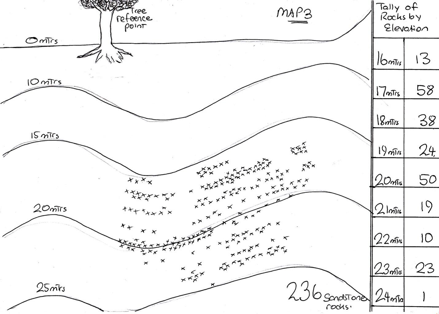
Figure 10 (Map 3): GPS placement of sandstone rocks [35]
Our search for sandstone rocks falls into three categories. On the southern edge of bigger mound, from an elevation of 24 metres down to zero, the women used one large tree as their common reference point and charted every rock visible on the ground (see Figure 10: Map 3). As directed no rock was touched by a woman but was counted, given elevation and GPS co-ordinates (see Tables below).
Less precise in positioning, but hopefully exact in tally, was the method adopted when counting the number of sandstone rocks/pieces found behind the smaller mound (see Figure 4, Map 2). Such was the number of rocks and short amount of time available, and the real chance it was merely sandstone fill for the mound, we chose to quickly count and scan the surrounds then attend to other tasks. What was quite notable was the exactness of the spread of sandstone, the irrigation/drainage ditch continued in both directions for hundreds of metres, but past either flank beyond the mound there was not one sandstone rock to be seen, anywhere.

Figure 11 (Table): GPS/Elevation of Sandstone Rocks
It did become apparent was that my assumption that all of the sandstone rocks on the smaller mound were fill was wrong; some rocks had obviously been worked, and this then made me question whether the stones that lay on the flats between the mounds were all from the larger mound.
Our third approach was the least precise and most rushed. This tally was taken on the second day when it was made clear the Spirits wanted haste. Taken from the northern edge/circle (see Figure 3: Map 1, {“Map A”}), we walked down the slope towards the flat and drew a circle every time a sandstone rock was sighted. Positioning was rough at best and it is most likely a margin of error of up to 10% should be factored in. Nevertheless, although incomplete, the final count of 115 is useful as an absolute minimum, and as a point of further investigation. What did surprise us was the size and weight of sandstone rocks and boulders lodged in the flat soggy area at the bottom of this ridge. Some weighed close to 50 kilograms and had straight lines, edges and 90 degree angles.
Not only were there two types of sandstone rocks, one worked into the desired shape and edging, while the others were un-worked and used as fill or was part of an arrangement, there also seems to exist a real chance more than one quarry or source of sandstone was accessed. Virtually every sandstone rock, regardless of the whether natural or exhibiting evidence of shaping and chiselling, is fine grained and deposited when the turbulence in the water depositing the sand had subsided.
At the time of writing we have identified one sandstone rock that breaks that mould (see figure 11). It is coarse grained: an agate or some form of crystal is embedded into the rock. The grains and pieces of rock that formed this rock were deposited when the flow of water was fast, and much further upstream than the overwhelming majority of sandstone found on site.
Figure 12: Coarse grain sandstone rock[36]
Once permission was gained, we intended to take one sandstone rock off site to be examined by geological expert of the highest order, and also take one piece of sandstone from the location Slater and his colleague thought the most likely quarry. Any comments in relation to make, origin and similarities or differences should assist greatly.
Of course, the tally of 851 sandstone rocks seen and tallied is literally the ‘tip of the iceberg.’ The farmer who ploughed these arrangements and terraces, rightfully so as his fathers’ land was under threat, is still alive and remembers using a disc plough. Which means wherever there is a cluster of sandstone, a common occurrence, the chances are even more rocks lay just below the surface. What is unfortunate was that some of the most substantial rocks were carefully placed inside the farmer’s barn, but alas, within a decade someone snuck onto their property and stole the rocks. We can only hope that person was not stealing but safeguarding the rocks until the day they can be returned, which is nearly upon us.
Another issue under consideration is Slater’s belief an actual Original alphabet of 16 letters existed and that some of those symbols were engraved onto rocks on the bigger mound. We do know that some symbols were engraved into some of the larger rocks that were stolen or kept under safe keeping, and there are markings on rocks on site that require much closer scrutiny, but at this stage we can offer nothing conclusive.
A Cross-Over Between Methodology
Confirming whether this is indeed the first formal piece of human communication, called the Sacred Language, and that the ‘Standing Stones’ detail the history of humanity and the “Mystic Track of Life”[37] seems an almost impossible task. Slater’s claim, that the first language is a seamless blend of hand signs, stone arrangements and alignments, body parts, symbols and numbers, and was first spoken in Australia, contradicts elemental assumptions that underpin our understanding of human evolution.
What appears to be even more puzzling is the content. The expectation is that first language would be the least sophisticated and most basic in expressing emotions, needs to survive, food and sundry concerns when trying to come to grips with just staying alive. Passages such as “the breath of god is the Divine light of the Soul,”[38] or “the light of truth flows like a river of fire from God to the soul of man and woman united,”[39] stand united in utter contradiction to the accepted scenarios. Instead of ‘what’s for dinner,’ or ‘Barry was here,’ we get statements of Divine Purpose and mystical insights.
Conclusion and Hypothesis
As radical the notion of the first language beginning in Australia may appear to be, we have already heard an Elder of the highest repute state that the first Original Language began in Australia (see YouTube: Egyptians in Australia Part 2)[40]. He also read of an interesting academic ruse that led the mischievous academic responsible (who is one of Australia’s leading experts in Original rock engravings) to admit that there is no less than a 50% chance all written language began in Australia.
It began as a ploy devised by Australian rock art expert, Professor Bednarik, to counter the criticisms subjected upon archaeologist Lesley Maynard. Maynard claimed that an ancient form of Original art, referred to as Panaramitee art and “characterized by thousands of small, pecked petroglyphs,”[41] was the precursor to all forms of language and written communication. But such was the intensity of the critiques that had been levelled at her “for some years”, Maynard stated she “was happy to bury it.”[42]
Bedanarik, aware that “some of the art of other continents resembled the Panaramitee,”[43] devised a simple questionnaire in defence of Maynard’s stance; one with a twist in the tail. “He sent out copies of seven unlabelled diagrams of engravings and asked eight rock art specialists to identify whether they were Panaramitee style or not. In fact they were all from North and South America, Africa and Europe. The score of wrong answers was an abysmal 98%”[44] in that nearly every response nominated Australia as the country in which this art was created. Bednarik was left with two alternatives; either that “it is not possible to identify a Panaramitee style, or … this is a world wide style.”[45] We, of course, subscribe to this world wide style originating in Australia then spreading throughout the globe.
Frederic Slater, the President of the Archaeological and Educational Research Society, was adamant not only did the First Language begin in Australia, but that he was able to access people who still knew the Old Ways and Tongue. However, in that respect, Slater made one of his very few errors. To begin with he displayed an acute appreciation for the depth and intricacies of the Sacred Language, but underestimated its resilience: “You are working in a much higher cult which I doubt is understood by present day Aborigines. The teachers have all gone.”[46] But we beg to differ. The “teachers”[47] are not gone, just out of sight until the time is right. And most assuredly one of those Elders, who spoke on behalf of others with similar knowledge of Lore and Sacred Language, was on site with us when counting rocks and chipping at the edges.
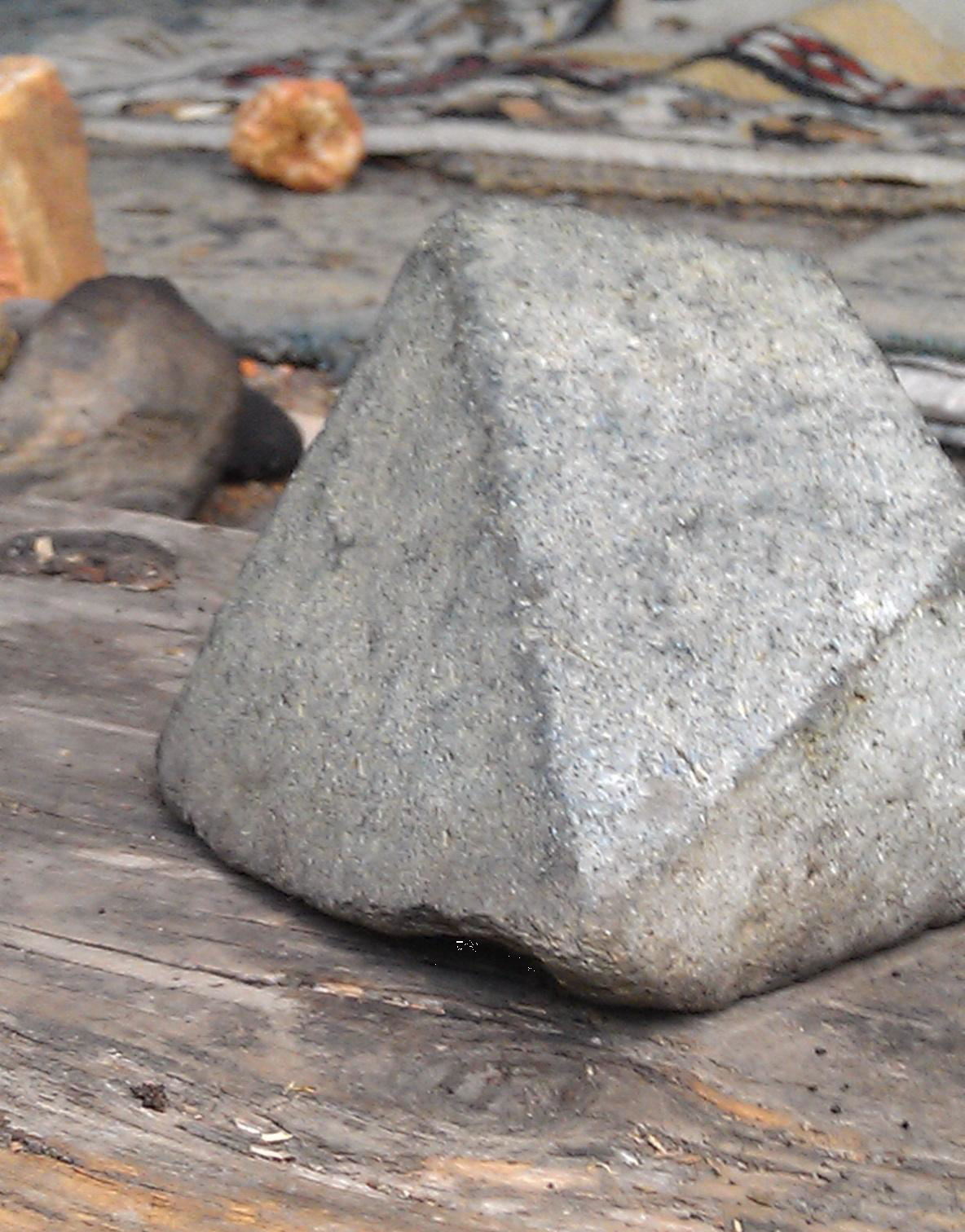
Figure 13: Pyramid rock capstone used southern circle[48]
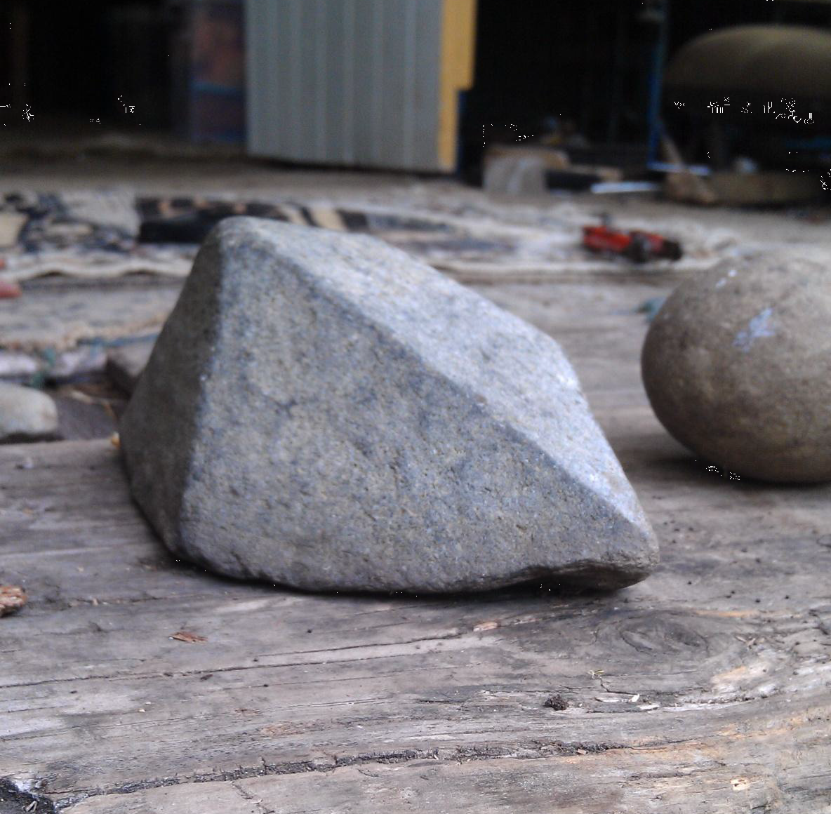
Figure 14: Pyramid rock capstone used southern circle (note accompanying rock)[49]
That small error aside, a man of his standing and knowledge, particularly in Egyptology, would only venture to make such challenging statements once fully armed with archaeological evidence of the highest calibre. The confirmation of his notes and interpretations along with a summary of some of the “28,000”[50] words Slater had assembled, by an Original Elder fully versed in these matters, appears to be sufficient in every respect.
When what we had always called the six-sided rock was brought onto country, the way it was used, along with the accompanying hand signs and gestures as the Elder shared the six, and at a later date seven, meanings this one rock subscribes, was just as Slater had described in his letters. The rock belonged to this sacred mound, and has since been placed under care by appropriate people. What we did see was exactly how it was positioned and understood in the past. Both President and Elder were in accord. With each word from the sacred Language having four meanings, there are “20 different forms of suffixes”[51] along with accompanying hand signs. This is, without doubt, the most difficult and mystical language ever spoken. And if this is indeed the very first time humans expressed their inner thoughts and inspirations, how far have we fallen?
The smaller mound promised so much, and from an archaeological viewpoint delivered very little. Fortunately, the little time that was allowed was ample for our purposes. With the exception of the small mound, all soil on the flats is a black/grey loam. The thousands of tones of exotic fill, sandstone and clay is a perfect road base simply because it bears no resemblance to the local swampy terrain. It was transported to this site, and equally there are sandstone rocks on site that weigh close to 50 kilograms.
There are records of Europeans, who were busy felling and burning trees, disturbing Original people on the mound in 1840, who fled with a few special rocks in hand. It is not a post-Cook construction, that is a fact. But equally, it has no equal in this country, and its construction requires a scale of quarrying and transportation that was supposedly never part of the Australian landscape until the British Invasion.
There are no sandstone deposits in this area, nor should there be. Geological maps and hours searching the surrounding area only confirm what Slater claimed in his correspondence; this sandstone was imported from somewhere far off. Whether it is a site 21 kms away, or much further as we suspect, will be resolved soon. But for now the distance is secondary, what can be stated is that it is a massive amount and it came from a long way off.
Many of the sandstone rocks found on the northern and southern slope have right angles, smooth faces and lines which seem to be very unnatural. All of these rocks were brought from afar, and leads us to conclude they have been quarried, transported, shaped and in some cases engraved, using technologies which were not supposed to be part of any pre-historic Original tool-kit.
So, in summing up, have our questions been answered?
In the case of the small mound/burial ground, yes. It is definitely an import, made from material brought from some distance. There are sandstone rocks by the thousands within and scattered around the edges, most were used for fill but a few were definitely worked and shaped. We have found quite a few of the stones that originally formed “the Mystic Track of Life,”[52] and have a map identifying the position of each rock which was charted about four months before it was reluctantly disc ploughed. The second, much bigger mound was most definitely levelled and terraced before the site was ploughed in 1940, this was also unheard of.
But of even more importance was the message written on this boomerang-shaped mound. It breaks every linguistic convention in relation to the content and way humans first spoke. Never the province of esoteric philosophers, the first language was assumed to be basic, few in number and crude in presentation. The Original Sacred Language is a sublime, sophisticated and spiritual merging of symbols, arrangements, hand signs, body parts, animals and numbers into the first spoken and written language.
There are more questions unanswered than resolved, and no doubt some of our explanations are quite radical and not without alternatives. Nevertheless, the smaller mound is totally unique in this country, the materials inside foreign to the surrounding countryside and the sandstone rocks do not belong. Something, be it the participants in attendance or the technology applied, was part of an equation that just doesn’t fit into accepted accounts of pre-1788 Australia.
If other civilisations were in this country, as both Slater and we ourselves are absolutely convinced, it would be remiss not to include Slater’s thoughts on this complex, not only about its presence but about its reverence. We are both in agreement in stating the Egyptians came to Australia as apprentices, to be tutored in the esoteric insights and cultural refinements that were a part and parcel of the Australian landscape and Original philosophy. “There is no mistaking the fact that the aborigines (sic) … gave not only to the Egyptians their knowledge and their foundation of hieroglyphics and their philosophy, but formulated the basis of all knowledge in the beginning, now and to come.”[53]
Rocks, dirt and archaeology aside, along with the multitude of questions raised, we believe all of this is secondary to the real gift and ultimate blessing this complex can bestow upon humanity in these uncertain times, and it has nothing to do with history or yesterday, but tomorrow. From the time the eight hawks first appeared on request, and even before, the Original Elders and Custodians were united in sensing the power and presence of the “Old Ones.”[54] And that has an impact on all of us irrespective of colour, creed or gender. As bold as Slater’s declaration was, in suggesting these mounds and messages “formulated the basis of all knowledge”[55] yet “to come,”[56] the Elders and Custodians are insisting that is exactly the case. It was before, and will be again.
Opinions aside, there are facts and historical irregularities that are, as Slater rightly observes, “of worldwide interest.”[57] Amongst all the excellent and sympathetic research, occasionally Slater erred, and one of his very few misunderstandings was his claim that this place is “the Stonehenge of Australia”[58]. The circles of standing stones at Stonehenge chart solstices and important astronomical events, the complex in Australia contains the “basis of all knowledge,”[59] astronomical markers, our First Language, solstices, religious tabernacles and humanities’ past history-beginning all the way back to Creation and spanning forward to future prophecies.
Maybe, just maybe, we have got it wrong. What is indisputable is that these standing stones, and all that surrounded them, just don’t fit into any accepted theory of human evolution, development or settlement. That is a fact. The rest of our research is a work in motion, its path in the hands of the Original Elders and Custodians of Lore. And as long as this harmonious arrangement and sequence continues, the truth will prevail and more facts will be revealed.
Acknowledgements:
We would like to offer our deepest gratitude to the following Elders and Custodians of Original Lore: Uncle Harry, Jarmbi’je, Karno, Iris, Darren, Scott, Adam, Mark, Kevin and Rob.
We also wish to thank all the volunteers on site, many of whom spent considerable time and money in helping, yet again, and did so for all the right reasons. Thank you so much: Jim Nutter, David Holstein, Erik Bower, Adam Gotllieb, Ryan Mullins, Gavin Bragg, Sarah Newsome, Richard Patterson, Paul and Phoebe Hoogendyke, John Sirigos, April Holloway, Binnah Pownall, Evan Strong, Dellene Strong and Cacey Blackburn.
Bibliography:
Flood, Josephine. Rock Art of the Dreamtime: Images of Ancient Australia. Sydney, Australia: Angus and Robertson, 1997.
. “Egyptians in Australia Part 2 – Steven Strong.” In Egyptians in Australia, 45:02. Australia: You Tube, 2012.
Patterson, Richard. “Coarse Grain Sandstone Rock.” (Photographer), 2013.
———. “Computer Generated Image of Standing Stones.” 2013.
———. “Sandstone “Shaped Stone”.” (Photographer), 2013.
———. “Smaller Mound / Burial Site.” (Photographer), 2013.
Slator, Frederic. 1939.
Strong, Evan. “Pryamid Rock 1.” (Photographer), 2012.
———. “Pryamid Rock 2.” (Photographer), 2013.
———. “Shaped Sandstone Rock 1.” (Photographer), 2013.
———. “Shaped Sandstone Rock 2.” (Photographer), 2013.
———. “Test Trench.” (Photographer), 2013.
Strong, Steven. “Diagram: Test Trench.” 2013.
———. “Map 1 of Western Slope of Bigger Slope.” 2013.
———. “Map 2: Smaller Mound and Scatter of Sandstone Rocks.” 2013.
———. “Map 3: Gps Placement of Sandstone Rocks.” 2013.
References:
1 Frederic Slator, 1939. Personal Correspondence, to (Name Withheld).
2 Ibid.
3 Ibid.
4 Ibid.
5 Richard Patterson, “Computer Generated Image of Standing Stones,” (2013).
6 Slator.
7 Richard Patterson, “Smaller Mound / Burial Site,” ((Photographer), 2013).
8 Slator.
9 Ibid.
10 Ibid.
11 Ibid.
12 Ibid.
13 Ibid.
14 Steven Strong, “Map 1 of Western Slope of Bigger Slope,” (2013).
15 ———, “Map 2: Smaller Mound and Scatter of Sandstone Rocks,” (2013).
16 Slator.
17 Ibid.
18 Ibid.
19 Ibid.
20 Ibid.
21 Ibid.
22 Ibid.
23 Richard Patterson, “Sandstone “Shaped Stone”,” ((Photographer), 2013).
24 Evan Strong, “Shaped Sandstone Rock 1,” ((Photographer), 2013).
25 ———, “Shaped Sandstone Rock 2,” ((Photographer), 2013).
26 Slator.
27 Ibid.
28 Steven Strong, “Diagram: Test Trench,” (2013).
29 Evan Strong, “Test Trench,” ((Photographer), 2013).
30 Slator.
31 Ibid.
32 Ibid.
33 Ibid.
34 Ibid.
35 Steven Strong, “Map 3: Gps Placement of Sandstone Rocks,” (2013).
36 Richard Patterson, “Coarse Grain Sandstone Rock,” ((Photographer), 2013).
37 Slator.
38 Ibid.
39 Ibid.
40 , “Egyptians in Australia Part 2 – Steven Strong,” in Egyptians in Australia (Australia: You Tube, 2012).
41 Josephine Flood, Rock Art of the Dreamtime: Images of Ancient Australia (Sydney, Australia: Angus and Robertson, 1997). 178.
42 Ibid.
43 Ibid.
44 Ibid.
45 Ibid.
46 Slator.
30
47 Ibid.
48 Evan Strong, “Pryamid Rock 1,” ((Photographer), 2012).
49 ———, “Pryamid Rock 2,” ((Photographer), 2013).
50 Slator.
51 Ibid.
52 Ibid.
53 Ibid.
54 Ibid.
55 Ibid.
56 Ibid.
57 Ibid.
58 Ibid.
59 Ibid.
About the authors:
Steven Strong is an Australian-based researcher, author and former high school teacher. Together with his son Evan, his work is to explore the ancient story of the Original people, a narrative that was almost lost to aggressive European colonisation.
Andy Whiteley an average 40-something from Melbourne Australia who, like many people, “woke up” and realized everything isn’t what it seems. Since then, he feels blessed to be a part of Wake Up World and its amazing community of readers.
This article © Wake Up World.
[pro_ad_display_adzone id=”110027″]